


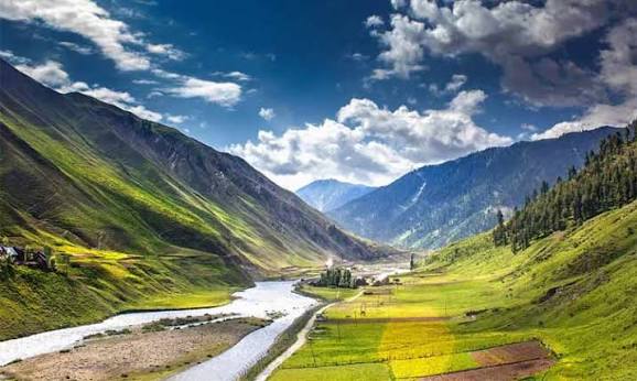
Tulail velley
*Tulail Valley - Short Summary* *Tulail Valley* Kashmir ki ek bilkul offbeat aur hidden gem hai. *Quick Facts:* - *Location*: Gurez Valley ke aage, Bandipora district me. LOC ke bilkul paas, Kishanganga river ke kinare - *Vibe*: Untouched, raw Kashmir. Bilkul crowd-free, sirf local Dard-Shina log rehte hain - *Best Time*: June to September. Baaki time snow ki wajah se band rehta hai - *Highlights*: Green meadows, wooden houses, snow peaks, Kishanganga river, peaceful villages like Badwan, Gano - *Special*: India ka last village "Tulail" hai. Yahan se Pakistan occupied Kashmir dikhta hai *1 Line Me*: Agar aapko "asli" aur shant Kashmir dekhna hai, bina tourist bheed ke, to Tulail Valley perfect hai. Ye trekking, photography aur culture lovers ke liye paradise hai.
About the Destination
*Tulail Valley: Kashmir's Last Hidden Paradise*
Tulail Valley is one of Kashmir’s most untouched and peaceful destinations. Located in the Bandipora district, beyond Gurez Valley, it lies along the banks of the *Kishanganga River* near the Line of Control.
This remote valley is home to the *Dard-Shina community* and is known for its traditional wooden houses, green meadows, and snow-covered peaks. Unlike popular tourist spots, Tulail has no crowds or commercialization - just pure nature and silence.
The valley comes alive from *June to September* when the roads open. Key villages like *Badwan, Gano, and Tulail* - the last village - offer breathtaking views of the mountains and river.
Tulail is perfect for offbeat travelers, photographers, and anyone looking to experience authentic rural Kashmir. It’s the starting point for peace seekers who want to see Kashmir beyond the usual.
*Note*: Inner Line Permit is required to visit.
### *3. Key Points / Bullet Version*
- *Location*: Bandipora district, after Gurez, near LOC
- *River*: Kishanganga flows through the valley
- *Culture*: Dard-Shina tribe & traditional architecture
- *Best Time*: June to September
- *Ideal For*: Offbeat travel, photography, cultural tourism
- *Vibe*: Peaceful, raw, untouched Kashmir
How to Reach
*How to Reach Tulail Valley, Gurez* 🏞️
Tulail Valley is the last valley of Gurez, right near the LOC. It’s offbeat, remote, and super beautiful.
### *Route from Srinagar*
1. *Srinagar → Bandipora*: 60 km, ∼2 hours via NH-234
2. *Bandipora → Dawar, Gurez*: 86 km, ∼4-5 hours via Razdan Pass
- This is the main road. Army convoy timing applies 8 AM - 4 PM
3. *Dawar → Tulail Valley*: 35-40 km, ∼1.5 hours further ahead
- Cross through villages like Badwan, Markoot, Chakwali
- Road ends at Ankot, the last village of Tulail
*Total Distance*: ∼185 km from Srinagar
*Total Time*: 8-9 hours one way
### *Key Points*
- *Road Status*: Open *May to November*. Closed in winter due to snow at Razdan Pass 3,292 m
- *Permits*: Indian tourists - ID proof needed. Foreigners need special permit from DC Office Srinagar/Bandipora
- *Transport*: Shared sumo/taxis available from Bandipora to Dawar. From Dawar to Tulail you’ll need to hire a local cab
- *Nearest Airport*: Srinagar Airport - 185 km
- *Network*: BSNL works in patches. No network in most of Tulail
### *Altitude of Tulail Valley*
*Altitude: ∼2,400 meters to 2,700 meters / 7,870 ft to 8,860 ft above sea level*
Dawar is at ∼2,400 m and villages like Ankot go up to ∼2,700 m. Weather is pleasant in summer, cold at night.
### *Quick Tips*
1. Start early from Srinagar to cross Razdan Pass before 4 PM
2. Carry cash, medicines, and power bank. No ATMs in Tulail
3. Stay options: Limited homestays in Badwan & Markoot. Book via local contacts
Want me to make a *"How to Reach + Map + Altitude" card* for Tulail like we did for Zero Point, so all 3 match on your site?